
Getting Around Santiago: A Practical Transport Guide
How to move around Santiago by Metro, Red bus, ride-hailing, funicular, and bike — the Bip! card, fares in pesos, airport transfers, smog timing.
Read the full guideUpdated · 14 min read
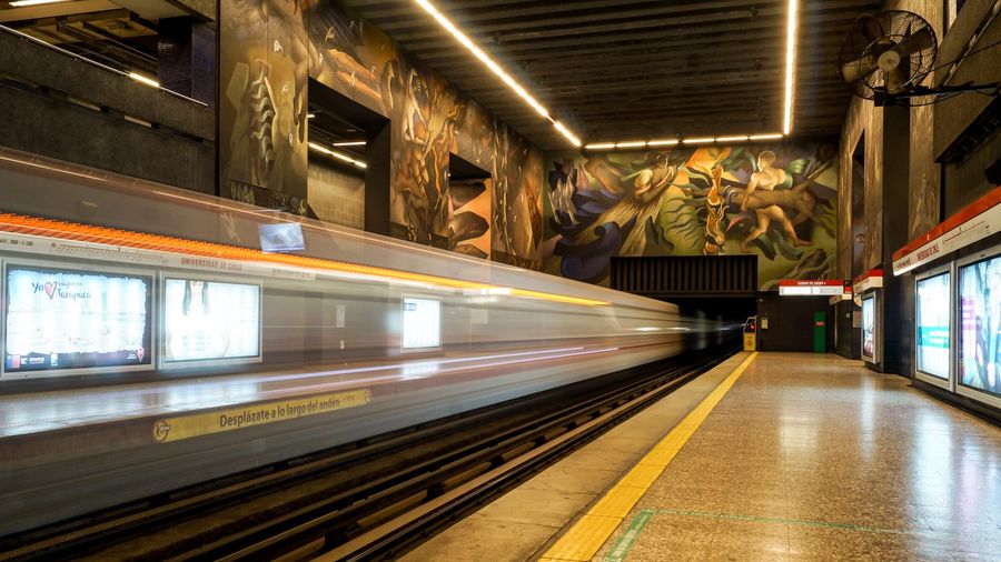
Getting around Santiago starts with a Bip! card, the rechargeable pass for the Metro and every Red city bus. A single ride costs a little under a US dollar, and one fare buys free transfers between bus and Metro for two hours. The colour-coded Metro covers the tourist core, Red buses fill the gaps, and ride-hailing closes the late-night window after the trains stop around 11 PM.
Santiago is easier to cross than its size suggests. The capital of Chile spreads across a wide basin between the coastal range and the Andes, but the neighbourhoods most visitors care about — the historic centre, Lastarria, Bellavista, Providencia, and Las Condes — sit in a compact spine that one of Latin America's best metro systems threads together for pocket change. The single most useful thing you can do on your first morning in Santiago is buy and load a transit card; almost everything else follows from there.
What is the Bip! card and do you need one?
The Bip! card is a rechargeable contactless card that pays for the Metro and every Red bus at the same fare, and it is essentially non-negotiable because buses no longer take cash. Buy one for a small fixed cost at any Metro ticket office, load it with pesos, and tap on as you board. A single card can pay for more than one passenger.
The Bip! card (pronounced "beep") is the rechargeable contactless card that pays for the Metro and every bus in the city's integrated Red Metropolitana de Movilidad network — usually just called Red. It is close to non-negotiable: Santiago's buses stopped accepting cash years ago, so without a Bip! you cannot board one at all, and while the Metro still sells single paper tickets, the card is faster and lets you use the free-transfer window.
Buy one for a small fixed cost (a few thousand pesos, including some initial credit) at any Metro station's boletería (ticket office) or the automated Autoservicio Bip! machines in station halls. Load it with cash — Chilean pesos only — and you are set. Crucially, one Bip! can pay for several passengers on a single tap-in at a bus door or a Metro turnstile, so a couple or a small group can share one card in a pinch. Keep a little credit in reserve so a busy top-up queue never strands you at a turnstile.
How does the Santiago Metro work?
The Metro is the fastest way across the centre — seven colour-coded lines that run clean, frequent, and cheap. Line 1 is the spine every visitor uses, tracing the Alameda past the historic centre, Universidad de Chile, and out to Providencia and Las Condes. Trains run roughly 6 AM to 11 PM on weekdays, with a single Bip! fare and free interchanges.
The Metro is the fastest way to cross the centre, and one of the reasons Santiago is so navigable. Seven numbered, colour-coded lines fan across the basin, but as a visitor you will lean on a handful:
- Line 1 (red) is the workhorse. It runs east–west beneath the Alameda — the city's grand central avenue — passing close to the historic core at Universidad de Chile (the mural-lined station pictured above, and the nearest stop to Plaza de Armas a few blocks north), then on through Providencia to the glass towers of Las Condes. It is the single most useful line for sightseeing, and the busiest.
- Line 5 (green) cuts diagonally through the centre and is your route to the Quinta Normal park and museums; it reaches Plaza de Armas in the historic core and interchanges with Line 1 at Baquedano.
- Line 2 (yellow) and Line 4 (blue) run north–south and are handy for reaching the outer residential districts, while Lines 3 and 6 add newer cross-town options.
Trains run roughly from 6 AM to about 11 PM on weekdays, with a later start on Sundays and holidays. A single Bip! fare takes you anywhere on the network with free interchanges between lines, and — thanks to the integrated Red system — a free transfer onto a connecting bus within about two hours. The trade-off is the crush: Line 1 through the centre is genuinely packed at peak times, and some stations run rush-hour express services (ruta expresa), where trains marked red or green stop only at alternating stations. Check the platform sign, or you may sail past your stop.
How do you use the Red buses?
Where the Metro stops, the Red buses take over, covering neighbourhoods the rails miss and running through the night. The learning curve is steeper than the Metro's — routes are numbered and lettered by zone — so the free Red app or Google Maps is essential for planning a bus journey and knowing where to tap on.
Where the Metro leaves off, the white-and-green (and formerly the notorious Transantiago) Red buses take over. They reach the neighbourhoods the Metro misses and keep running long after the trains stop, and they cost the same Bip! fare — with that fare often free if you are transferring from the Metro within the two-hour window.
The catch is the learning curve. Route codes mix letters and numbers by service zone (a 506, a C01, and so on), stops are not always obvious, and announcements are in Spanish only. The fix is your phone: the official Red app and Google Maps both plan Santiago journeys in real time, returning the exact bus, Metro, or walking combination and telling you which stop to wait at. Tap your Bip! on the reader as you board through the front door, and — unlike the Metro — there is no need to tap off.
When should you take a taxi or ride-hailing in Santiago?
After the Metro shuts around 11 PM, or for trips into the hills and outer suburbs, taxis and apps are the sensible choice. The black-with-yellow-roof metered taxis are plentiful; ride-hailing apps such as Uber and Cabify operate throughout the city, are generally cheaper, and spare you explaining your destination in Spanish.
After the Metro closes around 11 PM — or for a late dinner in Bellavista, a climb into the eastern barrios altos, or any trip the rails do not serve — taxis and apps take over. Santiago's official taxis are black with yellow roofs, metered, and easy to hail on the street or find at ranks; confirm the meter (taxímetro) is running when you set off.
For most visitors, ride-hailing is the smoother option. Uber and Cabify operate across the whole city, let you pay by card, and remove the friction of describing your destination to a driver who may not speak English — a real advantage late at night. Fares are reasonable by international standards, and a typical cross-town trip costs only a few dollars' equivalent. As the Santiago city guide notes, both are reliable throughout the city.
What about the funicular, bikes, and walking?
Two of Santiago's best experiences are their own form of transport. The funicular and cable car climb San Cristóbal Hill for the definitive Andes panorama, while the flat, tree-lined centre makes the Bikesantiago share scheme and simple walking a pleasure — Lastarria, Bellavista, and the Mapocho riverbank are best explored on foot.
Some of Santiago's most memorable rides are attractions in themselves. The historic funicular and the Teleférico de Santiago cable car both climb San Cristóbal Hill, whose summit delivers the view that recalibrates every visitor's sense of the city — the whole metropolitan basin below and the snowcapped Andes filling the horizon. These run on their own tickets, separate from your Bip! card, so budget a few thousand pesos for the round trip.
Down in the centre, the terrain could not be friendlier: Santiago's core is broad and flat, with a growing web of ciclovías (protected bike lanes) along the Mapocho river and the main avenues. The Bikesantiago share scheme puts thousands of bikes at stations across the central districts, and pedalling between Providencia's parks and the riverbank paths is one of the pleasantest ways to see the city. And do not underestimate walking. The bohemian Lastarria neighbourhood, the Bellavista backstreet that hides La Chascona — Pablo Neruda's secret Santiago home — and the colonial blocks around the Plaza de Armas are all best unpicked on foot, where the distance between adjacent sights is usually shorter than the wait for a train.
How do you get from the airport into Santiago?
Arturo Merino Benítez (SCL) sits 15–20 km north-west of the centre, and there is no Metro line to it yet. The cheapest route is a Centropuerto or Turbus airport bus to Pajaritos Metro station and on downtown; an official arrivals-desk transfer or a ride-hailing app is faster door to door, at 25–45 minutes depending on traffic.
Santiago's Arturo Merino Benítez International Airport (SCL) lies about 15–20 km north-west of downtown, and — for now — no Metro line reaches it, though an extension is planned. Your options, cheapest first:
- Airport buses — the Centropuerto and Turbus Aeropuerto services run frequently from just outside arrivals to Pajaritos (an interchange on Metro Line 1) and on toward the city centre, for a few thousand pesos. From Pajaritos you tap onto Line 1 with your Bip! and ride straight into town.
- Official transfer or taxi — book a shared or private transfer at the clearly marked counters inside the arrivals hall rather than accepting an offer from a tout in the concourse. Reckon 25–45 minutes to central hotels depending on traffic.
- Ride-hailing — Uber and Cabify serve the airport with designated pickup points; fares are usually a little below the taxi rate.
A word of advice: do not change all your money at the airport, where rates are poor. Bring or withdraw enough pesos to cover the ride into town and the cost of a Bip! card, then sort out better exchange in the city.
How much does getting around cost, and how should you budget?
Public transport in Santiago is genuinely cheap — well under a dollar a ride, with free bus–Metro transfers — so a week of heavy city travel barely registers. The larger transport costs are the optional day trips: a wine-valley excursion or a ski-resort transfer runs into the tens of thousands of pesos, and that is where a booked guide or driver earns its keep.
Everyday transport here is inexpensive. Individual Metro and Red bus rides cost well under a US dollar, and the two-hour transfer window means a bus-to-Metro-to-bus journey often counts as a single fare — so even a week of intensive sightseeing barely dents your budget. The funicular and cable car up San Cristóbal Hill are the main in-city extras, at a few thousand pesos each.
The costs worth planning for are the excursions beyond the Metro map. Santiago is the launch pad for the Maipo Valley Cabernet vineyards 30 minutes south and the cooler Casablanca whites an hour west, plus the ski resorts of Valle Nevado and El Colorado about 50 minutes into the Andes — none of them reachable by public transport. A rental car helps for the wine valleys, but for tastings (and the mountain switchbacks up to the snow) a booked driver or a guided day trip is safer and more relaxing. The Chile country guide breaks down typical tour and guide pricing in pesos and dollars, and the Santiago guide lists the going rates for city walking tours and wine-valley excursions.
How should you time your days in Santiago?
Two things shape the Santiago transport day: rush hour and smog. The Metro is busiest roughly 7:30–9:30 AM and 6–8 PM, when Line 1 fills and express services skip stops. Save outdoor viewpoints like San Cristóbal Hill for the morning or the day after rain, when the basin's summer smog clears and the Andes come into focus.
Plan around two rhythms. The first is rush hour: the Metro and buses fill from about 7:30 to 9:30 in the morning and again from roughly 6 to 8 in the evening, with Line 1 through the centre the tightest squeeze — and remember the rush-hour express trains that skip stops. Aim your Metro-dependent sightseeing at the middle of the day, and keep the walkable barrios for the peaks.
The second is smog. Santiago sits in a basin that traps pollution, and on still summer afternoons — and worst in winter under a temperature inversion — a haze can blur the mountains that are the city's signature backdrop. Schedule the high viewpoints, San Cristóbal Hill above all, for the morning or, better still, the clear day after rain, when the Andes snap into focus above the rooftops. On the clearest winter mornings the panorama from the summit is the most spectacular in any South American capital.
Why does a local guide still help?
None of this is hard after a day, but a local guide erases the learning curve. A good walking-tour guide hands you the Bip! and Red logic, steers you onto the right bus for the hills, times San Cristóbal Hill for a clear morning, and knows which Metro exit drops you at the door you actually want.
None of this is difficult once you have done it for a day, but a local guide compresses the learning curve to nothing. A good walking-tour guide will set you up with a Bip! card, explain the Red bus codes, know which exit at Universidad de Chile or Baquedano puts you closest to Lastarria, and time the climb up San Cristóbal Hill for the clearest air of the day. For a first visit, pairing a half-day guided orientation with a loaded Bip! card in your pocket is the fastest route to feeling like the city is yours.
Related Guides
- Getting Around Buenos Aires: A Practical Transport Guide — how another great South American metro city handles tap cards, buses, and airport transfers
- Planning the Perfect Trip to Bariloche — logistics for the Andean lake district, a popular onward leg across the border
- Mendoza Guided Tours — wine-country touring just over the Andes from Santiago
Sort out a Bip! card on day one, download the Red app or Google Maps, and the rest of Santiago opens up at the cost of a few hundred pesos a ride. The Metro gets you across the centre, the Red buses cover everything it misses, the funicular lifts you to the view, and a late-night ride-hailing app closes the loop after the trains stop — leaving you free to explore from the colonial centre to the foot of the Andes without ever wondering how you will get home.
Hero photograph of a train arriving at Universidad de Chile station by Rjcastillo, licensed CC BY-SA 4.0 via Wikimedia Commons.
Frequently Asked Questions
What is the Bip! card and do I need one in Santiago?
Bip! is the rechargeable contactless card that pays for the Metro and every Red city bus at a single fare. You need it because buses take no cash, and it is the simplest way onto the Metro. Buy one at any Metro station ticket office and top it up with pesos.
How much does public transport cost in Santiago?
A single Metro or Red bus journey costs roughly CLP 810–940 (about US$0.90–1.10) depending on the time of day, with the same Bip! fare across the network and free transfers between buses and Metro within a two-hour window. Fares nudge up periodically, so check the current price when you load your card.
How do I get from Santiago airport into the city?
Arturo Merino Benítez (SCL) sits about 15–20 km north-west of the centre. The Centropuerto and Turbus airport buses run to Pajaritos Metro station and on toward downtown for a few thousand pesos; an official airport-desk transfer or a ride-hailing app takes 25–45 minutes depending on traffic. There is no Metro line to the airport yet.
Is the Santiago Metro safe and easy to use?
The Metro is clean, frequent, and clearly signed, and it is the fastest way across the centre. Lines are colour-coded and numbered, and trains run roughly 6 AM to 11 PM on weekdays. As on any busy metro, keep your phone and wallet secure at rush hour, especially on Line 1 between Los Héroes and Tobalaba.