
Getting Around Ottawa: A Practical Transport Guide
How to get around Ottawa — walking the compact core, the O-Train light rail and OC Transpo buses, Presto fares, cycling the river pathways.
Read the full guideUpdated · 14 min read
Getting around Ottawa is easy and cheap: the core is compact enough to walk, and where it isn't, the O-Train light rail and OC Transpo buses cover the rest on a single Presto fare of about CA$3.80. Cycle the river pathways in summer, skate the canal in winter, and save a taxi for the airport run.
Ottawa is a capital built at a human scale. Unlike the sprawling metropolises where getting around eats half your day, Canada's capital keeps its headline sights packed into a walkable downtown wedged between the Ottawa River and the Rideau Canal. That geography is the single most useful thing to understand before you arrive: for a first-time visitor to Ottawa, the question is rarely how do I get there and more often do I even need to. This guide walks through paying for transit, when to use the O-Train versus your own two feet, how to reach the museums across the river in Gatineau, and how to time and budget your days so the logistics never get in the way of the sightseeing.
Is Ottawa walkable, and where should you start?
Yes — the downtown core is the most walkable in the capital region. Most marquee sights, from Parliament Hill to the ByWard Market, sit within a roughly two-kilometre radius you can cross in twenty-five minutes. Start on Parliament Hill, drop to the canal locks, and walk the market — an entire day without touching transit.
The heart of Ottawa is small, flat where it matters, and dense with things to see. From the lawns of Parliament Hill you can walk down to the eight-step flight of locks where the Rideau Canal meets the Ottawa River, then continue a few blocks east into the ByWard Market, one of Canada's oldest continuously operating farmers' markets. That single stroll, entirely free, links three of the city's defining places and takes in the Château Laurier and Confederation Square along the way.
A sensible on-foot sequence for a first day: begin with a morning tour of Parliament Hill, walk the canal locks and the riverside sculpture terraces, break for BeaverTails or a market lunch, then spend the afternoon among the shops and galleries of the market quarter. Only when you want the National Gallery, the war museum, or the museums across the river does the question of transport arise at all.
How do you pay for public transport in Ottawa?
Ottawa's transit runs under one operator, OC Transpo, on the Presto fare system. Buy and tap a reloadable Presto card, or simply tap a contactless bank card or phone straight on the reader. A single adult fare is around CA$3.80 (about US$2.80), valid for transfers within a time window, and a DayPass of roughly CA$11.75 caps a heavy day of riding.
Every train and bus in the city is run by OC Transpo, and they share a single fare system called Presto. You have two easy ways to pay as a visitor:
- Presto card. Buy the reloadable smart card at O-Train station machines, OC Transpo counters, and many Shoppers Drug Mart stores, load it with cash or card, and tap on when you board. It's the standard local method.
- Contactless tap. More convenient for a short stay, you can now tap a contactless credit or debit card — or the same card in a phone or watch — directly on the Presto reader and be charged the adult fare automatically. No card to buy, no balance to top up.
A single adult fare sits at roughly CA$3.80 (about US$2.80) and includes transfers between buses and the O-Train within its validity window, so a train-then-bus trip counts as one fare. If you expect several rides in a day, the DayPass at around CA$11.75 (about US$8.70) is the better deal — it pays for itself on the third ride. Fares nudge upward periodically, so confirm the current figure on the OC Transpo site before you budget to the dollar.
When should you take the O-Train instead of walking?
Take the O-Train for cross-town hops and to skip winter cold. Line 1, the Confederation Line, tunnels beneath downtown with stations at Rideau, Parliament, and Lyon, so you can surface a block from the market or the Hill. Line 2, the Trillium Line, runs north-south and branches out to the airport.
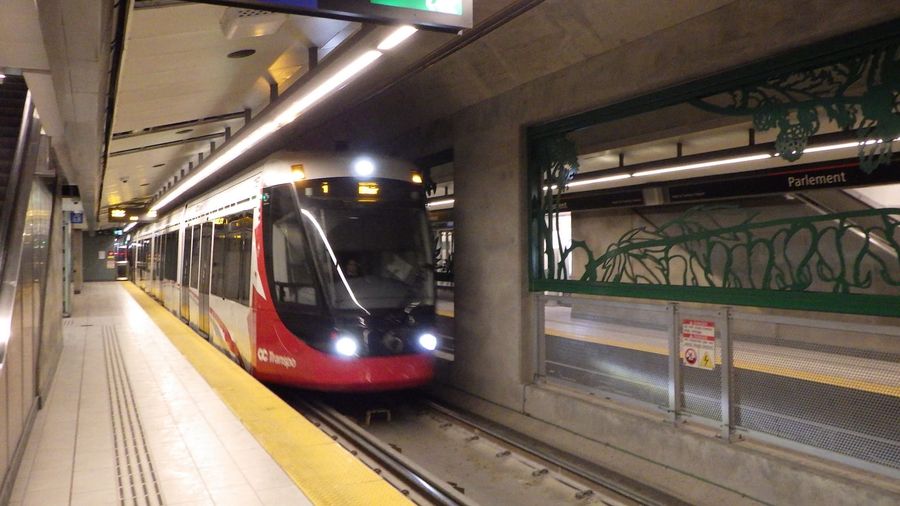
Ottawa's O-Train is its light-rail spine, and it is genuinely useful even in a walkable city. Line 1, the Confederation Line, opened in 2019 and runs east-west across the city in sleek red-and-white Alstom Citadis Spirit trains like the one pictured above. Its cleverest stretch is a downtown tunnel with three underground stops — Rideau (steps from the ByWard Market and the Rideau Centre), Parliament (beneath Parliament Hill), and Lyon — which lets you cross the core in minutes and, in February, dodge the deep cold entirely.
Line 2, the Trillium Line, is the older north-south route, rebuilt and reopened in 2025, and it now carries an airport branch that finally links the terminal to the rail network. For a typical sightseeing trip you'll lean on Line 1 far more than Line 2, using the train as a warm, fast shortcut between clusters of sights rather than as your primary way of seeing the city — that job still belongs to your feet.
How do OC Transpo buses fill the gaps?
Buses reach everywhere the trains don't, at the same flat Presto fare and with free train-to-bus transfers. Frequent routes fan out from the O-Train stations along dedicated Transitway corridors, and a bus is how you reach outlying sights, residential neighbourhoods, and the pathways trailheads without a car.
Where the two rail lines stop, OC Transpo's bus network takes over, and because train and bus share one fare with free transfers, switching between them costs nothing extra. Many routes run along the Transitway, a system of bus-only roads that lets them bypass general traffic — a legacy of the decades when rapid buses were Ottawa's rapid transit, before the O-Train took over the busiest corridors.
For a visitor, buses are the tool for the errands beyond the walkable core: reaching a trailhead for the Gatineau Hills, getting out to a suburban attraction, or returning to your hotel after the trains thin out late in the evening. Plan bus trips with a live app rather than a paper timetable, since frequencies drop outside peak hours and some routes are seasonal.
Is cycling a good way to see Ottawa?
In the warmer months, cycling is one of the finest ways to experience the capital. The National Capital Commission maintains hundreds of kilometres of paved multi-use pathways along the Ottawa River, the Rideau Canal, and the Rideau River, and rental shops near the canal put a bike within easy reach. The terrain is gentle and the scenery hard to beat.
From roughly May to October, Ottawa turns into a cyclist's city. The National Capital Commission (NCC) maintains an extensive web of paved, largely traffic-free multi-use pathways that trace the Ottawa River, loop along the Rideau Canal, and follow the Rideau River south. On many summer Sundays the NCC even closes selected parkways to cars for its Bikedays, handing the tarmac to cyclists, runners, and inline skaters.
Rental shops cluster near the canal and the downtown hotels, and rates are reasonable for a half or full day. Cycling the canal path from the downtown locks out toward Dow's Lake is a lovely, flat introduction to the city, and a bike collapses the distance to sights that feel just too far to walk. Bring or rent a helmet, keep to the marked paths in the busy core, and remember that these same corridors freeze into the Rideau Canal Skateway — the world's largest skating rink at 7.8 kilometres — once winter sets in.
How do you reach the museums across the river in Gatineau?
Ottawa's single best museum sits in another province. The Canadian Museum of History is in Gatineau, Quebec, a five-minute walk across the Alexandra or Portage bridge with Parliament Hill framed behind you. Cross on foot; just note that Gatineau's buses belong to a separate operator with its own fares.
Some of the region's finest sights are technically not in Ontario at all. Directly across the Ottawa River in Gatineau, Quebec, the Canadian Museum of History — with its sweeping Grand Hall of totem poles and the country's premier collection of Indigenous heritage — faces Parliament Hill from the opposite bank. The easiest way to reach it is simply to walk: the Alexandra Bridge and the Portage Bridge each deliver you across in about five minutes, and the view back toward the Hill from mid-span is one of the best free photographs in the city.
The one wrinkle to know is that public transit does not seamlessly continue across the river. Gatineau is served by its own operator, the Société de transport de l'Outaouais (STO), with separate fares from OC Transpo, so a Presto tap for an Ottawa bus won't carry you home on a Gatineau one. For the museum crossing this rarely matters — you'll walk both ways — but it's worth knowing before you rely on a bus back after dark.
How do you get to and from Ottawa Airport?
The Ottawa Macdonald–Cartier International Airport lies about 10 kilometres south of downtown. The O-Train's airport link now connects it to the Trillium Line for a standard transit fare, while a taxi to the core runs roughly CA$35 (about US$26) and takes 20 to 25 minutes — the better choice for late arrivals or heavy bags.
The Ottawa Macdonald–Cartier International Airport (YOW) sits about 10 kilometres south of Parliament Hill, close enough that transfers are quick and cheap. The headline improvement of recent years is that the O-Train now reaches the terminal: an airport link ties into the rebuilt Trillium Line, so you can ride into the city for a standard Presto fare rather than paying premium airport pricing — a rarity worth taking advantage of, though you should check the current connection at the station since the branch is new.
For late-night flights, groups, or anyone travelling with luggage and small children, a taxi or ride-hailing trip is the pragmatic choice. Expect around CA$35 (about US$26) into the downtown core and a ride of 20 to 25 minutes outside rush hour. Either way, the short distance means the airport transfer is one of the cheapest and least stressful legs of any Ottawa trip.
How much should you budget for getting around Ottawa?
Very little. A DayPass at roughly CA$11.75 covers unlimited train and bus travel, most days need only a single CA$3.80 fare or two, and walking the core costs nothing. The real line items are a bike rental, an airport taxi, and the paid attractions themselves rather than the transport between them.
Transport is the easy part of an Ottawa budget. Because the centre is walkable, plenty of visitors spend whole days without paying a single fare, and even an active day of museum-hopping rarely needs more than a couple of taps or one DayPass at around CA$11.75 (about US$8.70). Set against the typical cost of tours and guides across Canada, the getting-around line is close to a rounding error.
Where money actually goes is elsewhere: a half-day bike rental if you cycle, an airport taxi at roughly CA$35 each way if you skip the train, and the admissions and guided experiences you're here for. A group walking tour of the capital runs about CA$25 to 50 (roughly US$19 to 37) per person, and a private half-day guide considerably more — the meeting point will almost always be reachable on your own single fare.
How should you time your days in Ottawa?
Ottawa's seasons reshape how you move. Summer is for cycling the pathways and catching the Changing of the Guard; winter is for skating the canal and diving into the O-Train tunnel to escape the cold. In every season, check Parliament's sitting days if you want to watch Question Period, and start outdoor plans early on hot July afternoons.
Few cities change character with the calendar as sharply as the capital does. In summer, the river pathways, the Changing of the Guard on Parliament Hill, and the outdoor terraces are at their best — schedule cycling and canal walks for the morning on the hottest July and August days, and keep the air-conditioned museums for the afternoon. In winter, the Rideau Canal Skateway becomes the city's signature experience during the Winterlude festival, and the underground O-Train stations at Rideau and Parliament turn a bitter crossing of downtown into a warm two-minute ride.
One timing note applies year-round: if watching democracy in action appeals, check Parliament's sitting days before you go, since Question Period in the House of Commons is open to the public gallery only when the House is in session. Guided tours of the Hill run regardless, but the live debate is a scheduling prize worth planning around.
Why does a local guide still help in Ottawa?
Even in an easy city, a guide sharpens the first day: which O-Train exit lands you closest to your hotel, whether the canal is frozen firm enough to skate, and how the bilingual, two-province geography actually fits together. A half-day walking tour doubles as a transport orientation you'll use all week.
None of this is difficult once you've tapped on for the first time, but a knowledgeable local still smooths the small frictions that eat a first day in an unfamiliar capital. A good guide knows which O-Train exit puts you at the right corner of the ByWard Market, whether this week's cold snap has the canal frozen thick enough to skate, and how the bilingual, cross-provincial rhythm of Ottawa and Gatineau shapes everything from museum hours to which side of the river your bus belongs to. A half-day walking tour is the fastest way to absorb all of that: you finish it understanding how the trains, the bridges, and the pathways knit together, which turns the rest of your visit into a string of confident, single-fare hops.
Related Guides
- Getting Around Brisbane: A Practical Transport Guide — how another river-split capital handles tap fares, ferries, and airport transfers
- Planning the Perfect Montreal Trip — orienting yourself in Ottawa's bilingual Québécois neighbour a couple of hours downriver
Sort out a Presto tap on day one, learn that the O-Train tunnel is your winter shortcut across downtown, and the rest of Ottawa opens up on foot for the price of a coffee. Let the compact core do the sightseeing for you, save the taxi for the airport, and you'll spend your budget on Parliament tours and canal skates rather than on getting between them. For the full picture of what to see once you've sorted out how to move, start with the Ottawa city guide.
Hero photograph of an Alstom Citadis Spirit O-Train arriving at Parliament Station by Ahunt, released under CC0 1.0 via Wikimedia Commons.
Frequently Asked Questions
Do you need a car to get around Ottawa?
No. Ottawa's central sights cluster within about a two-kilometre radius that you can cross on foot, and the O-Train light rail plus OC Transpo buses reach almost everywhere else on a single Presto fare, so most visitors never rent a car.
How do you pay for public transport in Ottawa?
OC Transpo runs on the Presto system. Tap a reloadable Presto card, or tap a contactless credit card or phone directly on the reader, and a single adult fare is around CA$3.80 (about US$2.80). A DayPass of roughly CA$11.75 pays for itself after three rides.
What is the O-Train and where does it go?
The O-Train is Ottawa's light-rail network. Line 1, the Confederation Line, runs east-west through a tunnel beneath downtown with stations at Rideau, Parliament, and Lyon, while Line 2, the Trillium Line, runs north-south and now branches to the airport.
How do you get from Ottawa Airport to downtown?
The Ottawa Macdonald–Cartier International Airport sits about 10 kilometres south of the centre. The O-Train airport link connects it to the Trillium Line for a standard fare, and a taxi to downtown runs roughly CA$35 (about US$26) and takes 20 to 25 minutes.
How do you cross from Ottawa to Gatineau?
Gatineau, Quebec is a five-minute walk across the Alexandra or Portage bridge, and the Canadian Museum of History sits just over the river. Note that Gatineau's buses are run by a separate operator, the STO, with its own fares, so plan the return before you cross.