Getting Around Tokyo: A Practical Transport Guide
Everything you need to know about navigating Tokyo's world-class public transport system — trains, buses, IC cards, apps, and when to walk instead. Practical advice for first-time visitors.
Updated · 13 min read
Getting around Tokyo means mastering three rail systems—JR, Tokyo Metro, and Toei—tied together by a single rechargeable IC card (Suica or Pasmo) that you tap on every train, subway, and bus. The Yamanote Line loops the tourist core, Google Maps handles routing, and many neighbourhoods are a 10-15 minute walk apart.
Tokyo's transport network is the most impressive urban mobility system on the planet. It moves 40 million passengers daily across interconnected rail, subway, and bus networks with a punctuality record so precise that a 60-second delay triggers a public apology from the operator. For a first-time visitor, this system can feel overwhelming before it becomes indispensable. Tokyo fits into the broader context of Japan as a destination.
How is Tokyo's transport network structured?
Three separately operated systems cover Tokyo. JR runs the Yamanote Line linking Shibuya, Shinjuku, Harajuku, Ueno, and Akihabara. Tokyo Metro operates nine subway lines under the centre, reaching neighbourhoods off the loop like Ginza and Roppongi. Toei adds four more subway and bus lines, and private railways extend toward suburbs like Hakone.
Three distinct systems operate in Tokyo, each owned and operated separately:
JR (Japan Railways): The national rail company operating the Yamanote Line (the looping outer ring that connects Shibuya, Shinjuku, Harajuku, Ikebukuro, Ueno, and Akihabara), plus several commuter lines extending into surrounding prefectures. The Yamanote Line is your primary tool for moving between tourist-dense neighborhoods.
Tokyo Metro: The main subway network operating nine lines under central Tokyo. This is the fastest way to reach specific neighborhoods not on the Yamanote loop—Ginza, Aoyama, Roppongi, and others.
Toei: A separate subway and bus network operating four additional lines. Transfers between Tokyo Metro and Toei technically involve a separate fare, though IC card users rarely notice.
Private railways: Several private lines extend from terminal stations (Shibuya, Shinjuku, Ikebukuro) into suburbs and satellite cities. For tourist purposes, the most relevant are the Tokyu and Odakyu lines from Shinjuku toward Hakone.
What IC card do you need for Tokyo transit?
The IC card is the one thing every Tokyo resident uses. Suica (from JR East) and Pasmo (from private railways) are functionally identical, working on every train, subway, and bus, plus convenience stores and vending machines. Buy one at an airport or station machine and load ¥3,000 to ¥5,000 to start.
Before you arrive, find out whether your home country's contactless bank card works on Tokyo transit (most do not, or incur fees). The practical solution used by every Tokyo resident is an IC card:
Suica (issued by JR East) and Pasmo (issued by private rail companies) are functionally identical for transit. Both work on every train, subway, bus, and most convenience stores and vending machines across Japan.
How to get one: IC cards were temporarily unavailable for new tourists due to a supply shortage in 2023–2024. Availability has since improved; check the current status before departure. When available, purchase at airport vending machines on arrival at Narita or Haneda. Load ¥3,000 to ¥5,000 initially.
Where IC cards work: Every train and bus in Tokyo. Every 7-Eleven, FamilyMart, and Lawson convenience store. Many vending machines, lockers, and taxis. The card becomes your wallet for small purchases throughout the trip.
Topping up: Any ticket machine at any station (look for the IC card recharge option). Major vending machines also accept IC card top-ups.
When does the Japan Rail Pass make sense?
For a Tokyo-only trip, the Japan Rail Pass is not cost-effective—IC cards are cheaper for in-city travel. It pays off only across multiple long-distance journeys: a single Tokyo-Kyoto Shinkansen round trip, roughly ¥28,000 each way, already exceeds a 7-day pass. Calculate your actual JR usage and buy it outside Japan.
The Japan Rail Pass covers unlimited travel on JR-operated services including the Shinkansen bullet trains. For a Tokyo-only trip it is not cost-effective—IC cards are cheaper for in-city travel. The pass makes financial sense if you're traveling between Tokyo, Kyoto, Osaka, Hiroshima, or Nara, because a single Tokyo–Kyoto Shinkansen round trip (roughly ¥28,000 each way) exceeds the cost of a 7-day pass.
Calculate your actual JR usage before purchasing. The pass must be bought outside Japan (at a Japanese travel agency or licensed overseas retailer) or at designated JR offices immediately on arrival.
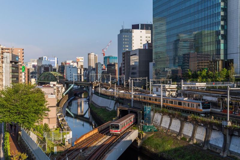
How do you navigate the Yamanote Line?
The Yamanote Line is the backbone of tourist Tokyo, a 35 km loop calling at 30 stations in both clockwise (sotomawari) and anticlockwise (uchimawari) directions. Choosing the wrong direction can add 20-plus minutes. Key stops include Shinjuku, Shibuya, Harajuku, Akihabara, and Ueno, each anchoring a distinct cluster of attractions.
The Yamanote Line is the backbone of tourist Tokyo. The loop runs approximately 35 km around the city's core, stopping at 30 stations in both clockwise (outer loop/sotomawari) and anticlockwise (inner loop/uchimawari) directions. The difference matters: if the station you want is clockwise from your current position, taking the anticlockwise train adds 20+ minutes.
Key stations and what surrounds them:
| Station | What's Nearby |
|---|---|
| Shinjuku | Government district, Golden Gai, Kabukicho, Omoide Yokocho |
| Shibuya | Scramble crossing, Harajuku, Cat Street, Daikanyama |
| Harajuku | Takeshita Street, Meiji Shrine, Omotesando |
| Akihabara | Electronics, manga, anime, traditional games |
| Ueno | Museums, Ueno Park, Ameyoko market |
| Ikebukuro | Department stores, Sunshine City, theater district |
| Shinagawa | Shinkansen interchange, quiet residential south |
Which navigation app works best in Tokyo?
Google Maps handles Tokyo transit with surprising competence, reading real-time delays, proposing alternatives, and showing IC card fares, so it suffices for most visitors. Yahoo! Transit Japan often finds marginally faster routes and is what commuters actually use. Hyperdia remains handy for bullet-train scheduling. Add 20 percent to walking estimates in dense areas.
Google Maps handles Tokyo transit with surprising competence. It reads real-time delay information, proposes alternative routes during disruptions, and knows the IC card fare for each journey. For most visitors, it's sufficient.
Yahoo! Transit Japan (Japanese language, with an English mode) often proposes marginally faster routes and is the app Tokyo commuters actually use. Worth downloading for complex multi-line journeys.
Hyperdia was long the gold standard for Japan rail planning but its website interface has aged. It remains useful for bullet train scheduling.
For walking navigation within neighborhoods, Google Maps works well but tends to underestimate time on Tokyo's dense city blocks where you often need to use pedestrian crossings rather than jaywalking. Add 20% to walking time estimates in crowded areas.
When should you take a taxi in Tokyo?
Tokyo taxis are metered, honest, and very expensive: ¥500 for the first kilometre, then about ¥100 per 400 metres, so a Shinjuku-to-Roppongi hop runs ¥2,000-2,500. They make sense after the last trains around 1 AM, with heavy luggage, for small groups splitting the fare, or in areas poorly served by rail.
Tokyo taxis are metered, honest, and extremely expensive by international standards. The starting fare is ¥500 for the first kilometer, then approximately ¥100 per 400 meters. A 5 km journey from Shinjuku to Roppongi costs around ¥2,000–2,500.
When taxis make sense:
- Late at night after the last trains (Yamanote runs until roughly 1 AM)
- When carrying heavy luggage between stations and hotels
- Small groups where splitting the fare competes with train cost
- Neighborhoods not well served by rail
Japanese taxi drivers almost universally do not speak English. Have your destination written in Japanese characters on your phone (Google Maps can display the destination address in Japanese) and show it to the driver. The left rear door opens and closes automatically—never grab it.
Ride-hailing apps: Uber operates in Tokyo in limited zones and at premium pricing. GO is the most popular Japanese ride-hailing app and has an English interface. Availability varies by area and time of day.
How do you get from Tokyo's airports into the city?
Narita sits 60-70 km out: the Narita Express reaches Shinjuku in about 90 minutes for ¥3,070, while the Keisei Skyliner hits Ueno in 41 minutes for ¥2,570. Haneda is far closer at 20 km—the Keikyu Line reaches Shinagawa in 17 minutes for ¥300, and the Monorail serves Hamamatsucho in 13 minutes.
Narita Airport is 60–70 km from central Tokyo.
- Narita Express (N'EX): JR service connecting Narita to Shinjuku, Shibuya, and Yokohama. Approximately 90 minutes, ¥3,070 one way. Covered by Japan Rail Pass.
- Keisei Skyliner: Private rail service to Ueno and Nippori. Approximately 41 minutes, ¥2,570 one way. Faster than N'EX for central Tokyo destinations.
- Limousine bus: Door-to-door service connecting terminals to major hotels. 90–120 minutes depending on traffic, approximately ¥3,200. Best for hotels not near train stations.
Haneda Airport is 20 km from the city center.
- Tokyo Monorail: 13 minutes to Hamamatsucho (Yamanote Line interchange), ¥500.
- Keikyu Line: 17 minutes to Shinagawa, ¥300. This is the faster choice for most central destinations.
- Limousine bus: Available to major hotels, 40–75 minutes depending on destination and traffic.
IC cards work on airport rail connections from Haneda. Narita connections charge a premium; IC card fares are higher than for regular in-city travel.
How do you cope with Tokyo's rush hour?
Tokyo's rush hour runs 7:30-9:30 AM on weekdays, when the Yamanote, Chuo, and major subway lines are packed so tightly that white-gloved staff push passengers aboard. Schedule sightseeing to start at 10 AM or later; evening rush from 5:30-7:30 PM is comparable but disperses faster. Women-only carriages are marked in pink.
Tokyo's rush hour runs 7:30 to 9:30 AM on weekdays. The Yamanote Line, Chuo Line, and major subway arteries are genuinely packed to the point that platform staff in white gloves assist with physical compression at the busiest stations.
Practical strategies:
- Schedule tourist activities that start at 10 AM or later to avoid morning rush
- Museums and major attractions are less crowded than if you'd arrived at opening time—but the commute is vastly easier
- Evening rush (5:30 to 7:30 PM) is comparable but often disperses faster
- Weekend trains are noticeably less crowded despite similar passenger volumes distributed across the day
If you must travel at rush hour, stand to one side of the doors to let passengers exit before entering. Women-only carriages (first and last cars on many lines, rush hour only) are clearly marked in pink; do not enter them.
When is walking faster than the train in Tokyo?
Tokyo's density means many journeys between apparent neighbourhoods take just 10-15 minutes on foot. Shibuya to Harajuku is a 15-minute walk along Cat Street; the train takes 3 minutes plus platform waiting and fare. Between adjacent Yamanote stations, walking often wins when the weather cooperates—but always wait for the signal, since jaywalking is frowned upon.
Tokyo's sheer density means that many journeys between apparent neighborhoods take 10–15 minutes on foot. The distance from Shibuya to Harajuku is a 15-minute walk along Cat Street; the train takes 3 minutes plus platform waiting and fare payment. Between major stations on the Yamanote, consider walking when the weather cooperates.
Neighborhood walking distances:
- Shibuya to Harajuku: 15 minutes
- Harajuku to Omotesando: 5 minutes
- Shinjuku to Kabukicho: 10 minutes
- Akihabara to Ueno: 20 minutes
- Ginza to Tsukiji: 15 minutes
Jaywalking is extremely rare in Japan and socially frowned upon even on empty roads. Wait for the signal.
How do you handle luggage on Tokyo's transit?
Tokyo's turnstiles and stairways aren't built for rolling suitcases, so two solutions are standard. Coin lockers at every major station hold most wheeled bags for ¥400-700 a day, though popular stations fill by mid-morning. Takkyubin delivery moves luggage between hotels or airports for around ¥2,000 a bag, letting you travel unencumbered.
Tokyo's train doors, turnstiles, and stairways are not designed for rolling suitcases. Two solutions are standard practice:
Coin lockers (coin rokka): Available at every major station in small, medium, and large sizes (¥400–700 per day). The large size accommodates most standard wheeled suitcases. Arrive early at popular tourist stations; Kyoto and Asakusa lockers fill by mid-morning.
Takkyubin delivery (kuroneko yamato, sagawa): Same-day luggage delivery between hotels (and to/from airports) for around ¥2,000 per bag. Book through your hotel or a convenience store. Your bags arrive the same day or next morning, allowing you to travel the rail network unencumbered. This is how experienced Japan travelers move between cities.
What are the key etiquette rules on Tokyo transit?
Five habits keep you in step. Stand on the left of escalators and walk on the right; take no phone calls on trains and avoid eating on commuter lines; queue at the platform markings where doors open; validate your IC card on exit as well as entry; and screenshot key maps for deep-underground sections.
- Stand on the left escalator side, walk on the right (reversed in Osaka — this matters if you're continuing there).
- No phone calls on trains. Keep phones silent; eating is also avoided on most commuter lines.
- Queue at the platform markings. Yellow lines and numbered spots indicate precisely where train doors will open. Join the queue.
- Validate your IC card on exit as well as entry or you will be overcharged or locked out.
- Screenshot key maps. Mobile data on Tokyo trains is good but not perfect in deep underground sections. A screenshot of the metro map and your day's route costs nothing.
How do guided tours use Tokyo's transport?
Many Tokyo tours build transit into the experience, structuring a Yanaka neighbourhood walk or a Tsukiji fish-market morning around trains rather than taxis because guides who know the network make it fast and legible. For self-guided visitors, mastering the trains unlocks every corner; for guided ones, it reveals why a guide picks a particular station exit.
Many guided tours in Tokyo include transit as part of the experience. A neighborhood tour of Yanaka or a morning fish market walk to Tsukiji is structured around trains, not taxis, because guides who know the network make it legible and fast. For a self-guided touring visitor, understanding the train system unlocks every corner of the city; for a guided visitor, it means appreciating why your guide chooses a particular entrance at Ueno Station rather than the more obvious one.
Related Guides
- Tokyo vs. Osaka: Which City Fits Your Trip? — comparing Japan's two largest cities and their respective transit cultures
- Bangkok Temple Tours — transport culture in another Asian megacity
- Los Angeles on a Budget — a contrasting study in a city designed around cars rather than rails
Tokyo's transit system rewards the traveler who takes fifteen minutes to understand its structure. Once you grasp the Yamanote loop, the IC card, and the logic of Metro versus JR, the rest of the city opens. What looks like a maze resolves into a precision instrument, and the city that seemed impossibly large contracts to neighborhood scale.
Preparing for a first visit to Tokyo? Reach out for route-specific planning advice before you arrive.
Frequently Asked Questions
Do I need a Japan Rail Pass for getting around Tokyo?
For travel within Tokyo, no. The pass only pays off across multiple long-distance bullet train trips. For city travel, a rechargeable IC card like Suica or Pasmo is far more practical.
What is an IC card and how do I get one in Tokyo?
An IC card is a rechargeable tap-to-pay card accepted on virtually all Tokyo trains, subways and buses, and at many shops. You buy and top one up at any station machine.
Is the Tokyo subway hard to navigate for non-Japanese speakers?
No. Stations and lines are colour-coded and numbered, signage includes English, and apps like Google Maps give accurate platform and transfer directions in real time.
How do I avoid Tokyo's rush hour crowds?
Trains are most crowded roughly 7.30 to 9.30 am and 5.30 to 7.30 pm on weekdays. Travelling outside those windows makes for a far more comfortable journey.